Advanced technology
for a world on fire.
Firebird applies AI, big data, and cloud-scale simulation to wildfire planning — transforming how communities, agencies, and utilities understand and mitigate risk.
- 10m
- Resolution
- 85%
- Accuracy
- B+
- Simulations
Wildfire intelligence, redefined.
Traditional wildfire models rely on outdated federal data with coarse resolution and limited accuracy. Firebird replaces guesswork with precision analytics — empowering decision-makers to act with confidence before the next fire season.
Our mission is to make complex wildfire analytics accessible, accurate, and immediately actionable for every stakeholder in the fire-risk ecosystem.
An AI-derived fuel model
at 10-meter resolution.
~70 remote sensing datasets, thousands of spectral bands, annually updated — engineered to outperform decade-old federal baselines.
Firebird Fuel Model
- ~70 remote sensing datasets (RGB, SAR, NDVI, IR)
- Thousands of satellite spectral bands
- 10-meter spatial resolution
- Annually updated
- ~85% accuracy at 10m resolution
Legacy Federal Data
- Single or limited data sources
- Coarse spectral coverage
- 30-meter spatial resolution
- ~10 years old
- ~55% accuracy at 30m resolution

Spectral Stack
Every pixel, classified — billions of observations distilled into landscape-grade truth.
Massive cloud-based fire simulations.
Firebird doesn't run a handful of scenarios. It simulates ignitions at every flammable pixel across the landscape — billions of data points for truly comprehensive risk assessment.
Multi-Ignition Approach
Simulates fires starting at every flammable pixel — not just selected ignition points — for complete landscape coverage.
Extreme Weather
All simulations run under 97th-percentile fire weather conditions to model worst-case, high-consequence scenarios.
Wind & Topography
Incorporates all relevant wind directions and full topographic effects for physically realistic spread modeling.
Billions of Data Points
Millions of simulations produce a statistically robust dataset that powers every risk metric and analytics layer.
Key risk metrics & analytics.
Firebird focuses on fire growth and transmission — the factors most critical for understanding structure loss and fatalities.
Explosive Fire Hazard
Identifies areas where fires can rapidly escalate within the critical first two hours post-ignition, enabling early intervention planning.
Landscape Transmission
Maps high-leverage corridors where fire consistently receives and transmits 3–5× the average fire load across the landscape.
Target Transmission
Computes how fire will transmit to specific high-value assets — structures, power lines, and water infrastructure.

Structure exposure & hazard.
Firebird analyzes the percentage of simulated fires that expose individual structures, and quantifies the potential for any single ignition to threaten multiple structures simultaneously.
Structure loss is the primary driver of wildfire disaster costs. Firebird's exposure analytics directly address this risk.

Power line exposure & hazard.
For each line segment, Firebird quantifies the acreage of fire exposure and the potential for that segment to threaten surrounding communities — informing vegetation management and real-time PSPS decisions.
Maximizing risk reduction.
Firebird's proprietary algorithm identifies the optimal treatment locations across the landscape to maximize reduction in structure exposure — pinpointing where intervention delivers the greatest return on investment.
Composite Index
Integrates intensity, explosive hazard, and transmission into a single holistic view of risk.
Decision-Grade
Translates complex analytics into prioritized investment and operational choices.
Potential reduction in structure exposure through optimized treatment placement.
Built for decision-makers.
Web-Based Interface
A Google Earth–like experience for creating projects, exploring risk layers, and generating custom maps from any browser.
Natural Language Queries
Build what-if scenarios in plain English — e.g. "landscape hazard index near power lines" — without writing code.
Customizable Layers
Built-in layers for fuels, structures, lines, jurisdictions, roads, population, and water — plus your own datasets.
Decision-Oriented Design
Every feature translates analytics into investment, scheduling, and operational decisions.
From raw data to actionable intelligence.
An end-to-end pipeline transforming satellite and sensor data into simulation-backed risk intelligence — annually updated, intuitively delivered.
Ingest
Stream 70+ remote-sensing datasets at landscape scale.
Model
Train AI fuel models annually at 10-meter resolution.
Simulate
Run billions of ignition simulations under extreme weather.
Analyze
Surface exposure, transmission, and optimization insights.
Who Firebird serves.
Forest Management & Government
Counties, states, federal agencies, and community mitigation groups use Firebird to prioritize treatment investments and communicate risk to stakeholders.
Electric Utilities
IOUs, co-ops, and municipal utilities leverage Firebird to prioritize vegetation management, assess infrastructure risk, and inform PSPS decisions.
Insurance Providers
Insurers use Firebird's portfolio-level analytics to assess exposure, price risk accurately, and identify mitigation opportunities at scale.
Why Firebird wins.
Superior Fuel Model
AI-derived, annually updated, 10m resolution — versus 30m, decade-old federal data. 85% vs 55% accuracy.
Multi-Ignition Simulation
Simulating every flammable pixel under extreme conditions produces a statistically complete risk picture — not a snapshot.
Exposure & Transmission Focus
Centering analytics on growth and transmission directly addresses the metrics that predict structure loss and fatalities.
The data speaks for itself.
A 30-percentage-point accuracy advantage translates directly into more reliable risk assessments and better-informed billion-dollar decisions.

Building the wildfire-risk ecosystem.
Integrated Field Services
Seamlessly integrate on-the-ground treatment execution with platform-driven risk analysis — closing the loop between insight and action.
Insurance Portfolio Risk
Partnerships with insurance carriers enable portfolio-level wildfire risk assessment, helping insurers price accurately and identify mitigation opportunities.
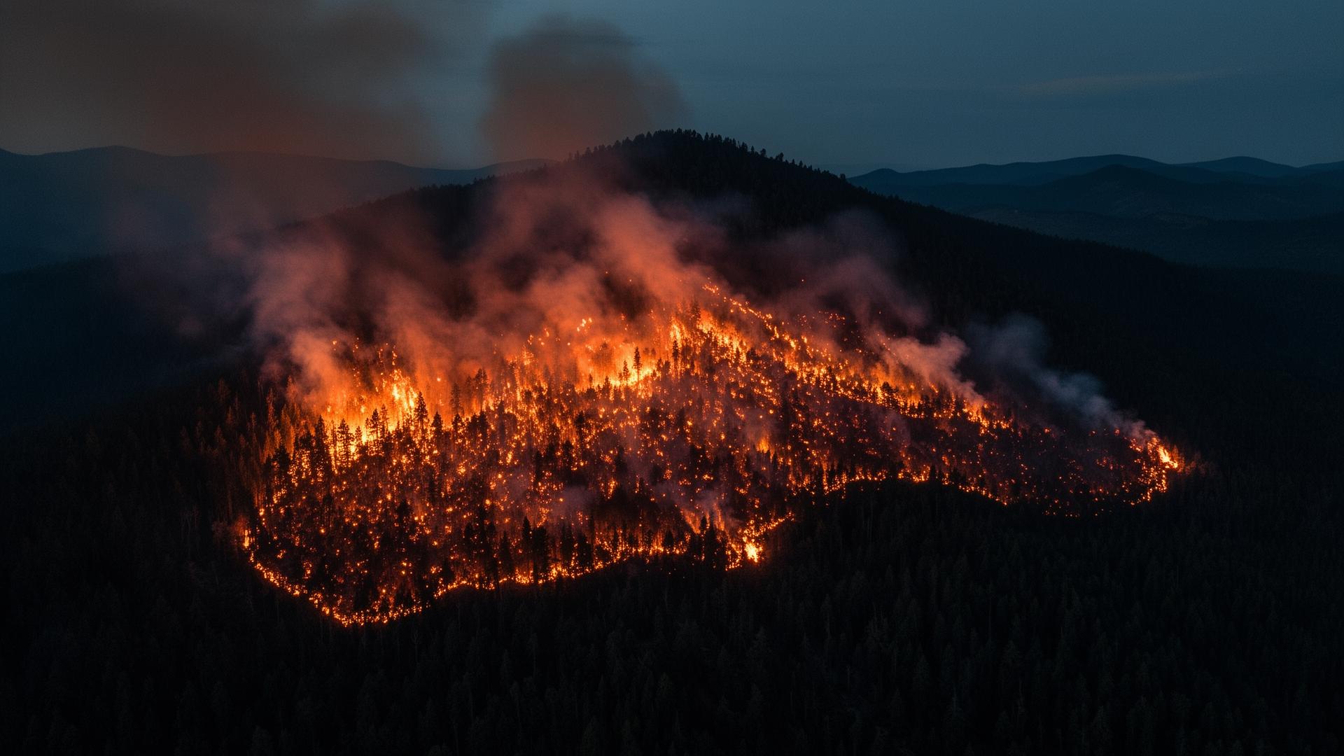
The stakes are too high
for outdated data.
Wildfires are growing in frequency, intensity, and cost. Communities, utilities, and agencies can no longer afford billion-dollar decisions based on decade-old models with 55% accuracy.
For Communities
Know which neighborhoods face the highest exposure and where treatment delivers the most protection.
For Utilities
Prioritize vegetation management along the highest-threat segments and make confident PSPS decisions.
For Agencies
Allocate limited mitigation budgets to the highest-leverage locations and demonstrate measurable outcomes.